About
The Project
St. Louis Metrolink Green Line (formerly Northside-Southside) will connect residents to growing job centers in Downtown West and Midtown, educational opportunities, and healthcare services making St. Louis a more equitable and thriving city for all people.
Project Goals
- Provide more choices and access to growing and established job centers for those with limited transportation options
- Invest in historically underserved or marginalized neighborhoods
Community Impact
By utilizing a long-term infrastructure investment, such as light rail, our region can improve access to economic opportunities for underserved communities. It will help preserve and stabilize St. Louis’ unique neighborhoods and change the futures of thousands of urban residents.
- 25% of households within walking distance of the alignment do not own a vehicle
- 10% of workers near the alignment rely on public transit to get to work
- 17% of all current affordable housing units (city-wide) are within walking distance of these new stations.
- Several parts of the alignment have the highest rates of transit use in the region.
Alignment and Route
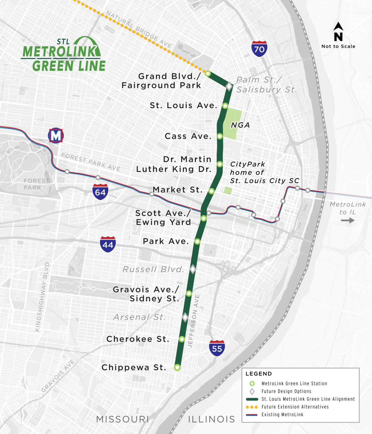
The St. Louis MetroLink Green Line is a dedicated lane, in-street, light rail project, which has been designed to 15% completion. It is 5.6 miles long and will travel from Fairground Park at Grand Boulevard, along Natural Bridge Avenue, east to Jefferson Avenue. Then south along Jefferson Avenue to Chippewa Avenue in South St. Louis.
The modified Green Line reflects public feedback and satisfies the goals of MetroLink expansion. More than 2,500 people provided feedback in 2023 during the 15% design phase. The majority overwhelmingly support the alignment but expressed concerns about property impacts and construction costs. Thus, the Green Line was reduced from 13 station to 10 with three design options. The three options are: Palm St./Salisbury St. Station, Russell Ave. Station and Arsenal Street Station. Reducing the number of stations decreases the physical footprint, improves travel times and reduces costs while maintaining access and an equitable transit system.
As part of this project, there will be 12 new light rail vehicles, a new transfer station for connection to existing MetroLink, and a dedicated maintenance facility at the existing Ewing Yard.
Project Map
Green Line will feature modern in-street light rail technology:
- Minimizes impacts to adjacent properties
- Operates in dedicated lane, separated by curb to enhance safety and travel times
- Enhances pedestrian experience with level station boarding
Team
A variety of groups will move this project forward.
PARTNERS
PMC TEAM:


Project Timeline
Environmental Review and 30% Design Phase
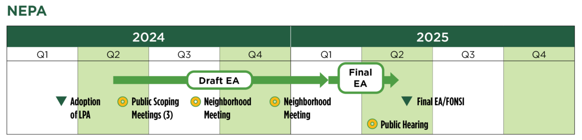
The MetroLink Green Line has advanced to the current environmental review and 30% design phase. NEPA (National Environmental Policy Act) requires that state or local governments seeking federal funds for a project conduct an environmental review. This review ensures the project does not significantly impact key environmental resources (i.e. air quality, water, natural habitats) or low-income individuals or communities of color. Other possible impacts to consider are parking, access, noise and parks. The NEPA process will take approximately 12 months.
During 30% design, project costs, timeline and major design elements will be fine-tuned. The project team continues to diligently work to identify cost savings.
During this process, the public has the ability to comment on the project, allowing community input and concerns to be considered. This ensures that community voices are heard.